3D View
3D View displays aircraft, sensor directions, ground footprints, and available targets on an interactive globe using the players' MISB metadata. It works with live and recorded mission playback.
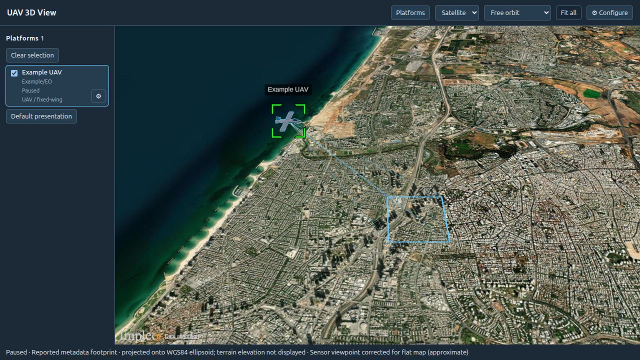
The 3D screenshots use example telemetry to illustrate the current STServer interface.
Opening 3D View
- Open VOD or Live and select a mission, platform, or sensor.
- Start video playback so that KLV metadata is available.
- Click the globe button labeled 3D View beside the map controls in the playback toolbar.
The globe opens in a separate window. The 2D map and 3D View can remain open together. The window receives metadata from the current page's video players, so a multi-sensor selection can show several feeds. Selecting another mission, replacing a feed, or seeking resets the affected feed's telemetry. Closing the player page or signing out closes its 3D window.
Allow pop-ups for STServer if the window does not open. Start 3D View from the playback toolbar rather than opening its URL directly.
Navigating the globe
Select a feed in the Platforms panel, then choose a view mode:
| Control | Behavior |
|---|---|
| Free orbit | Navigate independently of the platform. |
| Follow platform | Keep the selected platform in view as its position changes. Requires a valid position. |
| Sensor view | Look from the sensor using its orientation and field of view. Requires complete telemetry or applicable stationary-camera fallbacks. |
| Fit all | Frame the available platforms and their footprints, returning to Free orbit. |
| Clear selection | Deselect the feed and return to Free orbit. |
| Platforms | Show or hide the feed panel. |
If only one feed is available, choosing a tracking mode selects it automatically. In Sensor view, scroll or use + and − to zoom; Reset zoom restores the reported field of view. Zoom changes the viewpoint, not the video or footprint. Video is not projected onto the terrain.
Models and presentation
Click a feed's Config gear to edit its presentation, or use Default presentation for global defaults. Choose Global defaults, sensor defaults, or a feed override in the presentation selector.
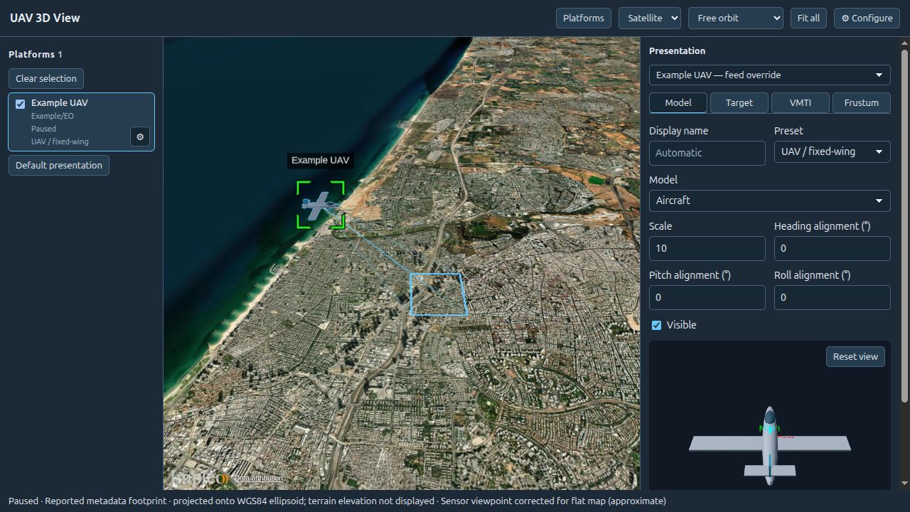
- Choose a model preset: UAV / fixed-wing, Helicopter, Quadcopter, or Stationary camera.
- Adjust model scale and heading, pitch, and roll alignment offsets. These offsets correct model orientation without changing sensor pointing.
- Configure VMTI and target visibility, footprint appearance, and aircraft-to-ground lines.
- For a stationary camera, supply position and mounting fallbacks for missing telemetry. Fixed height is measured in metres above the WGS84 ellipsoid.
Drag the model preview to rotate it, scroll to zoom, and use Reset view to restore its camera. Choose Save to apply the draft or Close to discard it. Resetting a sensor or feed override restores inherited settings. Overrides take precedence over sensor defaults, which take precedence over global defaults. Presentation settings affect the 3D display only.
Target location and VMTI
When KLV provides target latitude and longitude (tags 40 and 41), the globe can display a target crosshair and a connecting line from the aircraft. Without target elevation (tag 42), the target is placed on the ground. This target is independent of the frame center and VMTI detections.
Use the presentation Target and VMTI controls to adjust visibility. VMTI targets may appear as reported geographic outlines, estimated outlines projected from image boxes, or location markers. Estimated placement needs image dimensions and a usable ground footprint. Check the target tooltip for its placement method.
Uploading a model
Signed-in users with the user, groupAdmin, admin, or superAdmin role can upload models. Guests can use available models but cannot upload them.
- Open the feed's presentation settings and choose Upload beside the model selector.
- Select a GLB file, or a glTF folder containing its buffers and textures.
- Select the model entry if the folder contains more than one model, then click Upload model.
- Click Save in presentation settings to retain the selection.
Uploads support glTF 2.0 and are limited to 100 MB and 128 files. Include all referenced files; references outside the upload are rejected. Uploaded models remain in the shared library even if you close the presentation draft without saving.
Terrain and imagery
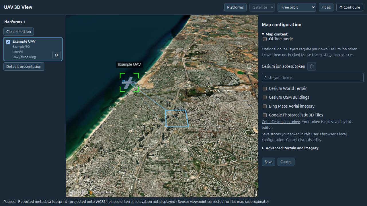
Use Satellite / Map to switch the base layer. Open Configure for custom imagery, terrain, and optional Cesium ion content. Choose Save to apply changes or Cancel to discard the draft.
The default terrain is the WGS84 ellipsoid. Optional World Terrain, OSM Buildings, Bing Aerial, and Google Photorealistic 3D Tiles require a Cesium ion token with access to the selected content. Custom terrain takes precedence over World Terrain. Google Photorealistic 3D Tiles replaces the visible globe while enabled; sensor calculations still use terrain or the ellipsoid rather than the photorealistic mesh.
For custom imagery, enter a tile URL template and match its XYZ/TMS layout, projection, image format, maximum level, and attribution to the dataset. Terrain sources must serve supported Cesium terrain tiles.
In Offline mode, online layers are suppressed. Configure local terrain and imagery services for the viewing browser; without imagery, the view shows a plain globe. A URL containing localhost refers to the browser's computer, not necessarily the STServer host. Keep provider credits visible.
Metadata and accuracy
Aircraft placement uses sensor latitude, longitude, and altitude, rather than frame-center coordinates. WGS84 ellipsoid height is preferred; mean sea level (MSL) altitude uses the bundled EGM96 approximation. Missing coordinates or altitude prevent placement. Incomplete attitude may leave a position marker instead of an oriented model.
Reported frame-center and corner coordinates define the footprint when available. Without reported corners, complete sensor geometry can estimate intersections with terrain or the ellipsoid. An Off earth endpoint hides the affected rays and edges; footprint fill requires four valid corners. Check the status line for missing or approximate geometry.
Live telemetry becomes Stale after five seconds without new data while playback is running, and old detections disappear. Paused playback retains its paused state. These displays provide situational context; estimated footprints and target outlines are not measurements of object size or surveyed coordinates.
Troubleshooting
- No window opens: allow pop-ups and click 3D View again.
- Waiting for metadata: select a sensor and check that its video contains KLV metadata.
- Feed listed without an aircraft: check visibility, coordinates, altitude, and attitude.
- Sensor view unavailable: check orientation and field-of-view data or the stationary-camera fallbacks.
- Missing model: select a replacement or restore the asset on the server.
- Online layer fails: check network connectivity, offline mode, and the ion token's access to the selected content.
Saving settings and assets
Map settings, presentation overrides, selection, and camera mode are saved in the browser separately for each server and user. Clearing site storage resets them. These settings do not change the server's global configuration.
Models are stored in the server's 3dmodels directory, or the path configured by MODELS_3D_DIR. Include that directory when backing up custom models.